

 1 hour ago
4
1 hour ago
4
PROTECT YOURSELF with Orgo-Life® QUANTUM TECHNOLOGY
Orgo-Life the new way to the future Advertising by Adpathway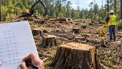
Representative Image (AI-generated)
A logging job that was supposed to take place on neighbouring property ended with 1,299 trees cut from a Mississippi couple’s land, turning a boundary mistake into a legal dispute over more than $40,000.
According to the Court of Appeals of Mississippi’s October 7, 2025 decision in Payne Logging LLC v. Gerald Smith and Rhonda Smith, the couple documented the damage with photographs and handwritten notes recording the number and diameter of trees they found cut. A chancery court awarded them $41,920, and the appeals court later upheld the judgment after finding that the evidence supported the number of trees cut and their location on the couple’s property.
Logging work crossed onto neighbouring property
Gerald and Rhonda Smith owned 36.5 acres in Tishomingo County, Mississippi, next to a 40-acre property owned by Robert and Joyce Hester. In 2022, the Hesters hired Payne Logging LLC to harvest timber from their property. The logging operation involved clearing a route between two parcels owned by the Hesters. According to the court record, Payne Logging cleared a road diagonally across the Smiths’ property while attempting to connect with a public road.
Trees were also cut along the Smiths’ northern boundary.The Smiths later argued that the logging company had crossed onto their property because the boundary used by the loggers was incorrect. The dispute eventually centred on exactly where the property line was located and how many trees had been cut on the Smiths’ land. Gerald Smith testified that he had spoken with Jon Payne before the logging began and told him not to cut trees on the Smiths’ property.
Smith said he also asked Payne whether he knew where the property boundaries were, and Payne indicated that he did.
On August 11, 2022, Rhonda Smith discovered that a path had been cut through their property. The court record described an existing trail that had previously been narrow enough for a four-wheeler but had been substantially widened by the logging operation.
The couple began documenting the trees
After discovering the cutting, the Smiths began documenting what had happened.
They took photographs of the affected areas and made handwritten records of the trees they believed had been cut. The handwritten tally recorded the number of trees and their diameters. Because the trees had already been cut, the couple measured the remaining stumps. The court record states that the trees had been cut approximately two to three inches above the ground.The Smiths made another tally after what they described as a second encroachment along the northern boundary on August 21, 2022.
Their records eventually counted 1,299 trees. Of those, 466 had diameters of seven inches or more, while another 833 were smaller than seven inches. The logging company challenged the accuracy of this tally. Payne Logging argued, among other things, that the Smiths had not measured the trees at the appropriate height because they measured the stumps after the trees had been cut.The appeals court, however, found that the evidence was sufficient to support the chancery court's findings.
The court noted that the trees were already gone, making it impossible to measure standing trunks in the usual manner. Testimony also supported the use of the stump measurements in determining the size of the trees.
Survey identified the actual property line
The location of the boundary became another important part of the case. Payne Logging had relied on a line that was used during the logging operation. According to the appellate decision, that line was at some points 180 feet away from the actual property boundary.The Smiths hired certified surveyor J.T. Strickland to determine the correct boundary. Strickland conducted a Class C survey and prepared a plat showing the property line. He testified that the boundary he identified was consistent with the property deeds and earlier formal surveys. His survey concluded that 4.62 acres of timber had been cut from the Smiths’ property. The chancery court accepted the survey evidence and found that the line used by Payne Logging was not the correct boundary.
The appellate court also noted that the evidence supported the conclusion that logging continued even after the company had been shown the correct property line.
How the $41,920 award was calculated
The damages were determined under Mississippi's timber-trespass law. The statute provides remedies when trees are cut without the property owner's consent and also allows additional damages when the cutting is wilful or done in reckless disregard of the owner's rights.
The Smiths did not provide evidence establishing the fair market value of the individual trees. Instead, the chancery court applied statutory per-tree penalties after finding that the cutting was wilful or in reckless disregard of the Smiths’ property rights.
The resulting judgment totalled $41,920.The award included $25,630 for the 466 trees measuring seven inches or more, along with $8,330 for the 833 smaller trees.
The court also awarded $1,155 in statutory reforestation damages, $5,500 in attorney's fees and $1,305 for the cost of the survey. The calculation therefore relied not only on the number of trees but also on their size category and other costs associated with establishing and addressing the damage.
Appeals court upheld the judgment
Payne Logging appealed the chancery court's decision, challenging the evidence concerning the number and size of the trees, the determination of the property boundary and the damages awarded to the Smiths.
The Court of Appeals of Mississippi ultimately affirmed the judgment in its October 7, 2025 decision. The appellate court found that the chancery court had sufficient evidence to determine that the trees had been cut from the Smiths’ property.
It also upheld the findings concerning the number of trees and the survey establishing the boundary. The decision left the $41,920 award intact.The case demonstrates how evidence gathered after an unexpected property dispute can become central in court. The Smiths’ photographs and handwritten tree tally helped document the extent of the cutting, while the professional survey provided evidence about the location of the property line. Together with testimony presented during the proceedings, that evidence supported the chancery court's findings, which were ultimately upheld on appeal.






















 English (US) ·
  French (CA) ·
  French (FR) ·