

 22 hours ago
6
PROTECT YOURSELF with Orgo-Life® QUANTUM TECHNOLOGY
Orgo-Life the new way to the future Advertising by AdpathwayOf Mountains and Horses is a five-day bikepacking journey from the Atlantic coast into the remote granite highlands of northwestern Portugal, crossing lush valleys, rugged mountains, and ancient villages along the way. It rolls through the wild region of Minho, where free-roaming horses, clear rivers, hot springs, and quiet backroads invite you to slow down and discover a side of Portugal far beyond the crowds...
Northwestern Portugal remains one of Europe’s most unknown bikepacking gems. Of Mountains and Horses is a 312-kilometer (194-mile) route linking the Atlantic coast to the rugged granitic highlands of Peneda-Gerês National Park, revealing a wilder, more authentic Portugal, far from the crowds of the south.
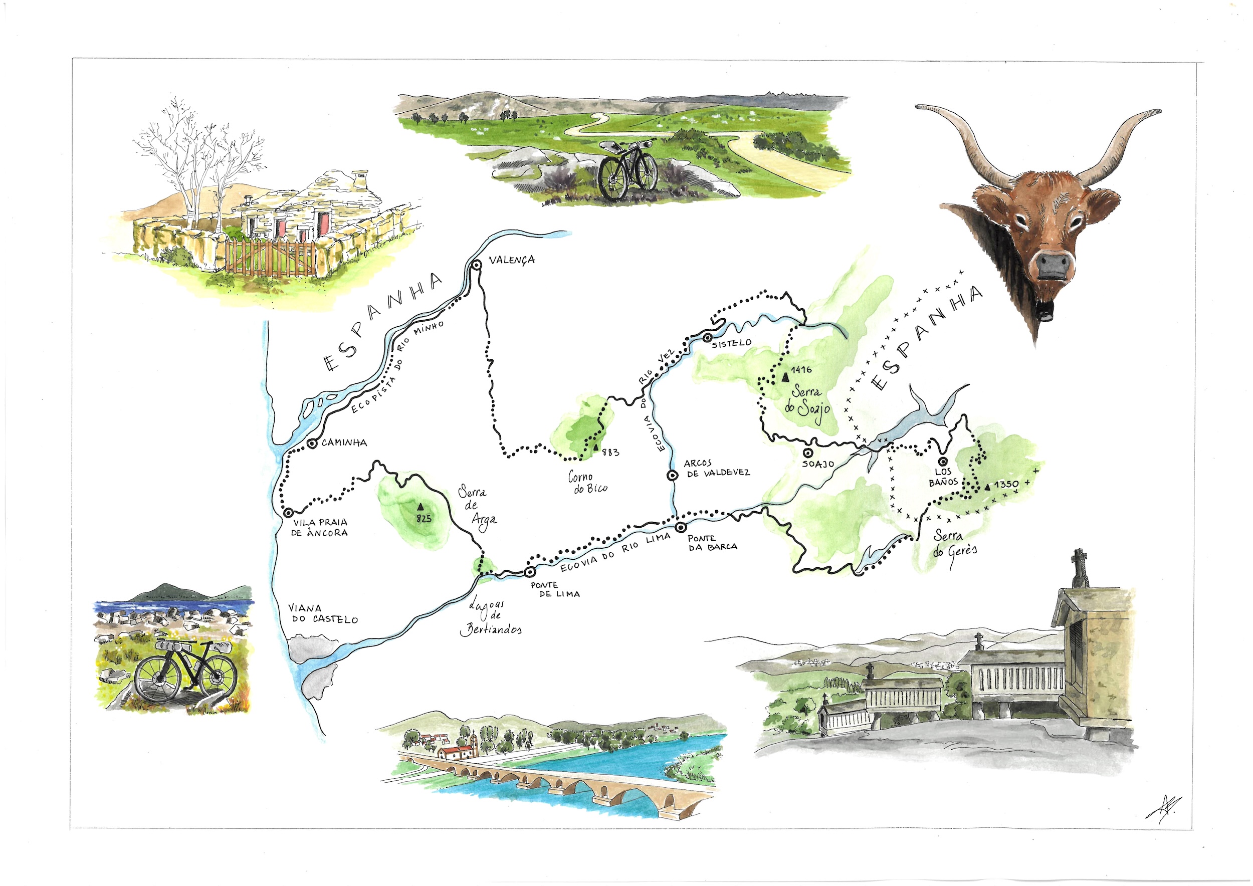
Minho is a region of contrasts. Stone villages give way to green valleys, forest tracks climb into the hills, and quiet country roads connect small communities where traditional ways of life are still very much part of the landscape—community is still a word in everyone’s vocabulary, and wildlife is still surprisingly free. Riding here means constantly moving between different environments, surfaces, and rhythms. Sometimes climbing hard through the rocky sections, sometimes rolling easily alongside a river, and sometimes stopping simply because a place, a view, or a conversation makes you want to savor that stillness. Each day brings something different, and a sense of discovery is at the heart of the route.
The route thrives on natural beauty, threading through protected landscapes such as the Corno do Bico Natural Reserve, the wavy Serra de Arga mountains, and the lush Vez Valley, all rich in biodiversity and cultural heritage. Medieval towns, stone bridges, and granite villages punctuate the journey, offering frequent reminders of the region’s deep rural roots.
Riders begin at Caminha’s train station, where the opening kilometers follow the Atlantic coast south before entering the Serra de Arga mountain range. It’s a gentle warm-up to what is otherwise a very mountainous route.
The main challenges come with the mountain passes of Serra de Arga, Peneda-Gerês National Park, Serra do Soajo, and Corno do Bico. Between these rugged ranges and their high granitic plateaux, the route drops into green, fertile valleys, following the Vez, Lima, and Minho rivers. All three feature cycle paths—some paved, others gravelly and rocky—that encourage a slower pace and immersion in the sound of running water and birdsong.
From Peneda-Gerês National Park, the route takes you shortly into Spain, along an old mining trail with rocky terrain and dramatic landscapes, connecting you to the town of Los Baños, where you can relax in the hot spring waters by the river, open and free 24/7.
The toughest and most remote section takes you to Serra do Soajo, a wild area, home to free-roaming Garrano horses, native long-horned cattle, and majestic griffon vultures. From there, the track descends into the Vez Valley, takes another climb to the Nature Reserve of Corno do Bico, after which it briefly intersects the historic Camiño de Santiago, and gradually rolls back by the Minho River towards the Atlantic Ocean, where wide beaches and fiery sunsets mark the final chapter of the ride.
Terrain varies from smooth forest tracks to stony gravel, greenways, and quiet paved backroads with almost no traffic. Designed with slowness in mind, this route rewards those who pause to swim in clear rivers, soak in hot springs, and savor northern Portugal’s wild landscapes.
Route Difficulty
The route offers a diverse mix of terrain and elevation, creating a balanced experience between easier, flowing sections and demanding mountain challenges. The gentler stretches generally follow the coastline and river valleys, while the harder terrain comes with the mountain passes. As you approach Serra do Gerês, the route enters its mountainous section, where most of the climbing is concentrated, taking you from sea level to about 1,200 meters.
The route has no major technical difficulties, though most unpaved sections are slow, including some steep climbs over harsh rocky gravel. Nevertheless, these sections remain rideable for the majority of the route. The hardest and longest climb is Serra do Soajo, where rough gravel can lead to occasional hike-a-bike sections or require strong technical riding skills. Be prepared for a challenging stretch between Soajo and Sistelo: approximately 47 kilometers with a long 18-kilometer climb up Serra do Soajo and no opportunities to resupply or refill your water. This is the only section that requires careful planning, so make sure you carry enough food and water before setting off. Beyond this demanding stretch, resupply is straightforward, as the route passes through small villages and offers manageable opportunities to restock throughout the rest of the journey.
Route Development
This route grew out of a series of journeys by the Women’s Bikepacking Portugal collective through the Minho region. Rather than being planned all at once, it came together slowly, shaped by local knowledge, multiple trips, and conversations within our community that kept us coming back to the same region. As a community of women who explore and adventure into the wild, we wanted to create a route other women could pick up with confidence, discover the magic of bivouacking in nature, and explore unbeaten off-road tracks. A journey that encourages curiosity and self-reliance while still leaving plenty of room for the unexpected discoveries that make bikepacking so special. In that sense, the route is a collective creation, shaped by the ones who have ridden and contributed to it.
Submit Route Alert
As the leading creator and publisher of bikepacking routes, BIKEPACKING.com endeavors to maintain, improve, and advocate for our growing network of bikepacking routes all over the world. As such, our editorial team, route creators, and Route Stewards serve as mediators for route improvements and opportunities for connectivity, conservation, and community growth around these routes. To facilitate these efforts, we rely on our Bikepacking Collective and the greater bikepacking community to call attention to critical issues and opportunities that are discovered while riding these routes. If you have a vital issue or opportunity regarding this route that pertains to one of the subjects below, please let us know:
Highlights
camera
Must Know
alert
Camping
home
Food/H2O
drop
Trail Notes
signpost
- Caminha: Known for its medieval clock tower and fair (held in the second half of July), Caminha is a charming town offering many restaurants and cafés where you can taste local food. A couple of kilometers south, the iconic dune landscape of Moledo Beach is not to miss, especially at sunset, when the colors are often golden.
- Nossa Senhora das Neves Sanctuary: The first high viewpoint along the route offers an unexpected panorama over the Minho River Estuary, stretching all the way to the Atlantic Ocean. It’s the perfect spot to take a break after the first section of the climb up Serra de Arga.
- Protected landscape of the Bertiandos and São Pedro de Arcos lagoons: Enjoy a ride through a quiet wetland area around the lagoons, with several marked paths, boardwalks and observation points along the way. It’s a well-known spot for birdwatching, so slow down and keep an eye out for the many species that live around the lagoons.
- Ponte de Lima: This is one of Portugal’s oldest towns, where you will arrive by crossing the famous medieval bridge and passing through the heart of the Camiño de Santiago. Because of its historical center and pilgrimage routes, Ponte de Lima has plenty of accommodation options, including a youth hostel, as well as plenty of bars and restaurants where you can enjoy a nice break.
- Río Caldo Hot Springs: The natural hot springs near the small town of Los Baños are the main reason this route crosses the border into Spain. They are free and available 24/7; just choose one of the small pools directly by the river and decide which one has the perfect temperature for your recovery.
- Mata da Albergaria: The route first reaches the Vilarinho das Furnas reservoir, built over an old village, whose remains can still be seen when the water is low. From here, it continues through Mata da Albergaria, one of the best-preserved oak woods in Peneda-Gerês National Park, before crossing the border into Spain.
- Soajo: This charming stone village is the perfect place to pause, eat a great meal, resupply, or even take a refreshing dip in one of the natural pools before tackling the longest climb of the route. Don’t miss its iconic granaries, a glimpse into the village’s rural traditions.
- Travanca Campsite: a quiet campsite at the gateway to Peneda-Gerês National Park, with everything you need for a comfortable stay. Wake up to a beautiful sunrise over the mountains (some well-known viewpoints are just five minutes from here), or cool off in the natural pools of Travanca. The campsite is usually open from 15 June to 15 September.
- Sistelo: After a long remote stretch, Sistelo is the first village with good commodities, where you can eat and resupply. Stop at a local restaurant to taste regional dishes before exploring this picturesque stone village, whose terraces and traditional mountain landscape are recognized as a National Monument. On the way to Sistelo, the route passes through the historic brandas of Aveleira and Santo António — seasonal mountain settlements once used for farming and grazing.
- Rio Vez Ecovia: From Sistelo, the route follows the river for around 8 kilometers, with several spots to stop and cool off in the natural pools. The trail mixes different terrain, including single tracks and narrow wooden boardwalks. During summer (1 July–30 September), some sections along the river can be particularly busy with pedestrians. During this period, where signs indicate, you must dismount and walk your bike.
- Corno do Bico Natural Reserve: this is the last mountain section before the route starts to flatten out towards the Camiño de Santiago that leads us to the Minho River cycleway. The route crosses the protected landscape through oak woods, small fields, and open mountain areas. Enjoy this last bit of climbing and quiet gravel before leaving the mountains behind.
When to go
- This route can be done during all seasons. Temperatures in this part of northern Portugal are milder than in central Europe. Nonetheless, we consider the best time to do it to be from late April to October, when nature is at its best: you can swim in mountain waterfalls, rivers, and beaches. If you enjoy an immersive cultural experience, during the summer months (especially August) you will also be treated to multiple festivities in the small villages, enhancing your bikepacking experience.
- You should also know that in this part of Portugal it can rain a lot, especially during spring, and that’s why it’s so lush green. In summer, be prepared for the heat, and in winter expect some flooded trails with winter waterfalls. In any case, be ready for changing weather, given the mountain ranges the route goes through.
Logistics
- If you travel by plane, the easiest is to take a flight to Oporto, and then either catch a train to Caminha (bikes allowed and free of charge, although you have to book a ticket with a bike. Or just ride there. It’s around 115 kilometers to Caminha following the EuroVelo (EV1) or around 95 kilometers taking the Camiño de Santiago to Ponte de Lima.
Dangers and Annoyances
- Stray dogs: Anywhere in Portugal, be very attentive to the stray dogs.
- Wildfires: During summer, wildfire risk is real (and frequent) across the entire Portuguese territory. Check Fogos.pt and activate alerts for your location. If there is a fire nearby, do not wildcamp and reroute to main roads if necessary.
- Natural pools: For safer swimming, the best conditions are generally between May and September. Always take care around waterfalls, rivers, and natural pools.
Travel basics
- This route crosses the border from Portugal to Spain and back. If you are traveling from outside of the European Union, please consider this when applying for visas.
What bike
- The best bike is a hardtail mountain bike, although a gravel or rigid mountain bike with a minimum of 40-45mm tires might be suitable with good technical skills. There are some technical climbs and rocky singletrack sections, but they are not too long, and if necessary, you can hike-a-bike those short sections.
Several campsites are listed on the POIs. Some may be closed in winter, so please check online before you arrive whether they will be open. Some campsites with bungalows may be open year-round. Wild camping is forbidden in the total protection area of Peneda-Gerês National Park (this area is around Serra do Gerês and Serra do Soajo, and it can be viewed on the following official map.
There are plenty of water fountains along the route, but some might not always be safe. If they have a sign stating “Água não controlada”, it means the water is not tested for chemical contaminants, but many villagers still use it and drink it, so the best way is to ask a local if it is safe to drink. If there’s nothing written, it means it’s okay to drink. If it says “Água não potável”, it is not safe to drink. In summer, carry at least 1.5 or 2 liters with you. You’ll also find small cafes in most villages you pass through, although supermarkets and restaurants are less common (mostly in bigger towns). Please see POIs for detailed information.
Suggested Itinerary
locationCaminha to Ponte da Barca
Day 1 (76km, +982m)
If you arrive in Caminha by train, head to the town center to grab supplies and something to eat before the start, and watch the ocean one last time before heading into the mountains. You can stay the night at Orbitur campsite if you prefer to have an early start. The first part of the track takes you to Vila Praia de Âncora, passing through the iconic wooden boardwalk at Moledo Beach, where dunes mix with granite rocks along the coast. After 10 kilometers, you will start the first climb of the route up to Serra de Arga. You start on a gravel track through the woods and soon reach the first highlight, where you can pause to refill your water bottles and eat before continuing the second part of the climb. This part takes you along a panoramic road, passing through small villages (the first one, Dem, should have an open café). The descent ends at the protected wetlands of Bertiandos and S. Pedro de Arcos, where you will take the Lima Ecovia for about 6 kilometers before crossing the medieval bridge and arriving in Ponte de Lima. This is one of the biggest towns you will cross and has all the amenities you could need, including a bike shop if you need some last-minute maintenance. Continue for 16 kilometers along the Lima Ecovia, following the riverbank and crossing some beaches along the way, before arriving in Ponte da Barca. In this medium-sized town, you could stay for the night. Another option is to continue 12 kilometers by the river until the Lima Escape Campsite (See POIs).
locationPonte da Barca to Los Baños
Day 2 (76km, +1,710m)
From Ponte da Barca, you will continue on an easy gravel track along the river until you cross the Touvedo Dam, where you can catch a glimpse of the mountains you will climb over the next few days. From here, you start the second long climb, with approximately 850 meters of elevation gain, towards Brufe. This part takes you through small mountain roads with very little traffic. If you need a break after this long climb, head to the terrace of “O Abocanhado”, a classy restaurant where you can also stop for coffee or ice cream while enjoying a 180-degree view over the valley. On the way down, you enter Peneda-Gerês National Park, cross the Vilarinho das Furnas Dam, and ride along a smooth gravel track with magnificent blue-and-green views until Mata da Albergaria. Near the border, you can see one of the most frequented natural pools and waterfalls in Gerês, although bike access may be difficult because of the steep approach. After crossing the border, you will enter a remote 25-kilometer mountain bike stretch that follows an old mining path. This is a relatively technical section, including the descent onto the road to Los Baños, so be prepared. In Los Baños, you can eat at the thermal bath restaurant and, finally, recover your sore legs in the hot springs by the Caldo River.
locationLos Baños to Branda da Aveleira
Day 3 (64km, +1,690m)
A couple of kilometers after Los Baños, you will find a gravel track that undulates through the mountains, revealing impressive granite walls. The track takes you to the border, where you cross into Portugal and follow a main road for approximately 4 kilometers. It is a wide road with no particular danger, but keep in mind there may be some traffic because it connects to Spain. After leaving the main road, you’ll start the route’s longest climb: about 18 kilometers with 1,050 meters of elevation gain to the highest point at 1,220 meters. Nearly 2 kilometers into the climb, you will pass through the village of Soajo, where you can stop to eat (don’t miss the best local meat burgers at “Taberna o Nativo”), rest, and resupply. The first 10 kilometers of the climb follow a paved road. You will pass through Travanca, a popular tourist spot with some of the best mountain viewpoints, accessible waterfalls, and a campsite, before entering a technical, rocky path through a very remote area. At the top, you will reach a granite plateau that is a real landscape gem, with free-roaming Garrano horses, photogenic long-horned cattle and, if you are lucky, griffon vultures circling high above. The track continues to Branda da Aveleira and Branda de Santo António, two traditional seasonal mountain settlements with ancient stone shepherds’ huts. One of them could be your home for the night (see the POIs for reservations).
locationBranda da Aveleira to Corno do Bico
Day 4 (45km, +937)
After Branda de Santo António, you start a long and rough gravel descent into the village of Sistelo. Roughly halfway through the descent, you’ll find a hidden gem: access to a natural pool by the river. This will be your first contact with the Vez River, which you will follow along for half of today’s route. Known as “The Portuguese Tibet” because of its green terraced farmlands, the village of Sistelo is the only one you’ll cross that day. This means you can take a break at one of the restaurants or cafés, explore the stone village, and try to resupply for the next stretch. Next to the natural pool of Sistelo (see POIs), you will enter the Vez River Ecovia for approximately 8 kilometers. This Ecovia is one of the route’s main highlights, with lush vegetation, wooden bridges and boardwalks, and beautiful natural pools that invite you to take several breaks and cool off along the way. The first 4 kilometers have restricted access for bikes during summer (from the beginning of July until the end of September) because of the high number of hikers on this trail. For safety reasons, during this period it’s preferable to walk this part of the trail. There are amazing spots to swim along the way, where you can stop and enjoy the magical green scenery of the Vez valley. After leaving the valley, you start the route’s last long climb, which takes you to the Corno do Bico Natural Reserve. About halfway up, there’s a picnic area with public toilets and drinking water. The second part of the climb (from Lamas) takes you through mountain bike trails with no chance of resupply.
locationCorno do Bico to Caminha
Day 5 (62km, +293)
Leaving the highest point of Corno do Bico Natural Reserve, where you’ll find a picnic area and a fire lookout tower, the route slowly takes you into the protected landscape, with the chance of crossing paths with some free-roaming horses. The descent follows mountain bike trails, which can get a little technical depending on the season, before joining the Camiño de Santiago. From Agualonga to Valença, you’ll follow the pilgrimage route, sharing the way with hikers and fellow cyclists. After the mountains and climbs of the past few days, the terrain finally opens up, with no more major climbs between you and the ocean. From Valença, enjoy around 30 kilometers of pleasant, flat cycling along the Minho River banks. It’s the perfect stretch to relax your legs, take in the scenery, and get ready for the final arrival in Caminha, where the Atlantic awaits.
Terms of Use: As with each bikepacking route guide published on BIKEPACKING.com, should you choose to cycle this route, do so at your own risk. Prior to setting out check current local weather, conditions, and land/road closures. While riding, obey all public and private land use restrictions and rules, carry proper safety and navigational equipment, and of course, follow the #leavenotrace guidelines. The information found herein is simply a planning resource to be used as a point of inspiration in conjunction with your own due-diligence. In spite of the fact that this route, associated GPS track (GPX and maps), and all route guidelines were prepared under diligent research by the specified contributor and/or contributors, the accuracy of such and judgement of the author is not guaranteed. BIKEPACKING.com LLC, its partners, associates, and contributors are in no way liable for personal injury, damage to personal property, or any other such situation that might happen to individual riders cycling or following this route.
Further Riding and Reading
Here are some connected/nearby routes and related reports...
Please keep the conversation civil, constructive, and inclusive, or your comment will be removed.















 English (US) ·
 French (CA) ·
 French (FR) ·